
For Immediate Release –
San Rafael, CA –
Annual efforts prepare county for possibility of rainy winter season
With long spans of dry weather and devastating wildfires in recent months, it is easy to forget how the Marin County’s winters can be exceptionally wet and that serious flooding and property damage is a risk for parts of the community.
In an ongoing effort to improve public safety, the annual storm season preparations by the Marin County Department of Public Works (DPW) and its contracted agencies have been completed across the region, a crucial job for flood mitigation and stormwater drainage.
“Preparing for storm season is a major undertaking that we work on year-round,” said Liz Lewis, Water Resources Manager. “By the time there’s significant rain on the horizon, we’ve generally been finished with the prep work for months. We hope that’s comforting to the public.”
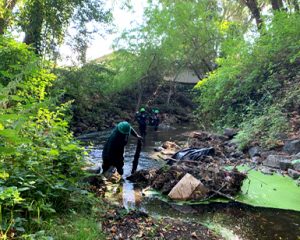
County Flood Control teams and North Bay Conservation Corps crews work together to clear debris, dead vegetation and fallen trees from creeks across Marin county. This intensive work helps reduce flood risk by maximizing creek capacity during storms when water levels run high.
Storm season preparations, which are conducted every summer and usually completed by fall, cover a wide range of work on creeks, levees, tide gates and pump stations. Tasked with this responsibility in parts of Marin, the Marin County Flood Control and Water Conservation District identifies issues and manages improvements in eight flood control zones across Marin. The zones do not cover the entire county and are, for the most part, concentrated in the county’s eastern urbanized corridor. The District oversees more than 50 miles of creeks and channels, 14.23 miles of levees and berms, 1.34 miles of floodwalls, 17 pump stations, 8 portable pumps, and several stormwater basins across the region.
Many areas of Marin are not within one of the flood control zones and therefore are not under the District’s supervision. The infrastructure not covered by the District includes state-maintained roadways such as Highways 37, 101 and 1, which are overseen by California Department of Transportation (Caltrans). DPW and District staff communicate with Caltrans to help strategize short and long-term solutions to ongoing flooding issues on Caltrans’ property, such as Manzanita Park & Ride at the Highway 101 and Highway 1 interchange and Caltrans short term improvements at 37 in addition to DPW’s research study of Highway 37.
Summer creek maintenance is a major part of storm preparations to maximize runoff flow. The District works with local agencies, such as the nonprofit Conservation Corps North Bay, and municipal public works departments to handle maintenance on 18 creeks across the eight watershed zones. Teams perform essential vegetation management along creek banks, remove sediment as needed, and remove obstructions such as trash and dead trees across the channel to maximize flow capacity.
This summer, the District conducted a sediment removal project on lower reaches of Novato, Warner, and Arroyo Avichi creeks. The project targeted approximately 1.5 miles of creek bed from Diablo Avenue, near downtown Novato, to downstream of the railroad tracks off Rowland Way, just behind the Century Rowland Plaza movie theater. Clearing out the sediment helps reduce overtopping of the creeks during storms and subsequent flooding for the surrounding communities.
In September, the phase 1 excavation of the eight-acre Sunnyside Basin near Fairfax began, marking a milestone in the San Anselmo Flood Risk Reduction Project. Ultimately the basin will have a 33 acre-feet capacity to store floodwater during storms. The project is designed to improve public safety and reduce flood risk for residential and business properties along Fairfax and San Anselmo creeks in the Ross Valley, a region that has suffered significant property damage during storms for decades.
Each year, the District inspects 43 pumps housed at 17 stations across Marin’s flood control zones to ensure that they are functioning at optimal efficiency. The pumps play an essential part in flood reduction for neighborhoods such as Tiburon’s Bel Aire, Strawberry Circle, Santa Venetia, lower Tamalpais Valley and Novato. The pumps transport stormwater from low-lying lands into creeks, facilitating natural water flow out to San Francisco Bay.
The District coordinates with DPW’s Building Maintenance and Fleet Operations divisions to complete annual service on all pump stations, including wet wells, electric motors and natural gas engines. The District performs major maintenance for each pump on a six-year cycle, which includes full extraction and cleaning of the machinery.
The Cove pump station near Tiburon recently underwent a complete overhaul. The project helped maximize the effectiveness of the station, which was originally built in 1976, and installed back up power to the station. The facility is now compatible with future planned upgrades to the surrounding area’s stormwater drainage system.
The District and DPW crews also inspect, maintain and repair levees as part of the overall storm prep protocol. Standard maintenance includes inspecting levees and timber reinforced berms for weak points, fortifying with supportive material and filling rodent burrows to prevent leaks. This is conducted on levees in the areas of Richardson Bay, Ross Valley and Santa Venetia.
Roadway work, handled by DPW’s Road Maintenance Division, is an important part of storm season preparedness. Annual practices require inspecting and cleaning roadside storm drains using a process called vactoring. Conducted in early fall, the process removes debris buildup and reduces the chances of clogging during storms. Compared with other areas of Marin, Tamalpais Valley, Marin City, Strawberry and Santa Venetia require significantly more vactoring because of their low elevation and propensity for flooding.
There are hundreds of roadside drainage ditches along arterial and rural roads in unincorporated Marin, and those require attention as well. Upkeep on the ditches helps control stormwater flow and minimize roadside flooding and erosion. Hundreds of culverts, inlets and flow pipes are inspected and, if needed, cleared along all County-maintained roads.
During fall, roads crews sweep streets to keep debris out of drains and creeks. They use two large street-sweeper trucks and run routes across areas of unincorporated Marin with the densest concentration of trees along the neighborhood streets of Sleepy Hollow, Oak Manner, Loma Verde, Marinwood, Country Club, Greenbrae, Kentfield, Strawberry, Tamalpais Valley and Marin City.
The District maintains a total of 18 rainfall and creek flow gauges across Marin, helping predict potential, localized flooding events and providing real-time data to respond in a more targeted manner. In the long run, data analysis will help develop designs for new flood mitigation projects.
Residents are encouraged to take action prior to the rainy season to help mitigate flooding of private property, including the clearing of dead leaves from driveway pipes, rooftop gutters and storm drains. Dead foliage should be disposed of in compost bins, not left in street gutters to clog drainage systems. Those living in flood-prone areas should test their sump pumps and stock up on sandbags (available at most hardware stores) and learning how to properly use them prior to storms. Additionally, ReadyMarin.org[External] provides many detailed resources, including emergency grab-and-go packing checklists, that can be helpful for residents to prepare for the unexpected.
It is important for residents to sign up for the Alert Marin notification system to be aware of emergency situations that could carry life safety implications, such as floods. The service, provided by the Marin County Sheriff’s Office, provides the public with time-sensitive alerts targeted toward specific addresses or neighborhoods. Residents who have registered should review their contact information to ensure it is up to date. Alert Marin is different from the Nixle[External] service, which provides general public safety and/or post-disaster information.
Flood insurance is important for homeowners and renters alike, as it goes beyond what is covered under standard insurance policies. Even a few inches of water can result in thousands of dollars in repair and restoration costs. Marin County participates in the National Flood Insurance Program, which makes federally backed insurance[External] available for all structures, and provides a range of resources to help property owners make the best decisions. Residents who seek such coverage are encouraged to contact their insurance agency but should be aware that it takes approximately 30 days to process, so advanced planning is advised.