
For Immediate Release –
San Rafael, CA –
Part of a new Bay Area radar system, led by Sonoma, to be installed on Mount Barnabe in West Marin
Extreme weather systems, such as atmospheric rivers, have hit California with increasing frequency in recent years. The average damage from floods caused by atmospheric rivers in California is now over $1 billion per year. Marin County has experienced its share of these intense storms and the damages are both costly and disruptive. In times of emergency, accurate and timely forecasts are critical for cost-effective risk-based decisions regarding public safety response measures, infrastructure operations, and essential resource allocation.
The Marin County Department of Public Works (DPW) is collaborating with local, state and federal agencies, with Sonoma County Water Agency (SCWA) as the project manager, on weather radar installations at key locations across the greater San Francisco Bay Area. The result will be a regional weather prediction system that uses enhanced weather radar to track atmospheric rivers.
This public safety and emergency response improvement project is funded by grants from the California Department of Water Resources (DWR), California Office of Emergency Services (CalOES) and Federal Emergency Management Agency (FEMA).
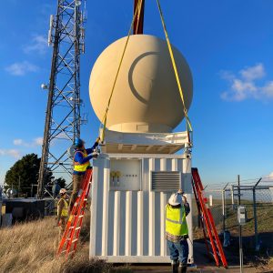
The system, known as the Advanced Quantitative Precipitation Information (AQPI) project, includes two types of radar, X-band and C-band, which are being installed across various counties in the Bay Area. Five X-band radar installations will be placed in counties outside of Marin and a single C-band radar installation will be placed on top of County-owned Mount Barnabe in West Marin. The Mount Barnabe location currently has a MERA radio installation and a Marin County Fire Department lookout tower in proximity to the planned C-band radar installation, so electricity and internet connections are already in place.
An online community meeting was held February 15 to discuss the details of the project and answer questions for residents living in the vicinity of Mount Barnabe. The Marin County Board of Supervisors will consider SCWA’s proposed lease agreement for the Mount Barnabe site at the March 7 public meeting.
The C-band radar will be mounted about 10 feet above the ground on top of a 24-by-16-foot concrete pad. The 10-foot diameter golf ball shaped “radome” encloses and protects the radar antenna from the elements. To minimize visibility, the structure will be painted beige to better compliment the surrounding environment and blend in with the color tones of the hillside.
The C-band radar system uses a directional antenna to focus the beam in a specific direction, like how a lighthouse creates a narrow beam of light, and then scans vertically and horizontally to produce an image of the atmosphere. The radar will not exceed Federal Communications Commission (FCC) recommended radar levels for general population and is below all applicable regulatory standards. Also, because the radar will be placed 10 feet above the ground, the radar beam will be higher than the tallest person in the area.
Having a C-band radar on Mount Barnabe provides a clear view of the Pacific Ocean, which is where atmospheric rivers start. As storms hit land and move toward the Bay Area, the radar will track precipitation as it falls. The location on top of the mountain will also give great coverage of the populated areas of Marin. In Sonoma, Contra Costa, and San Mateo counties, the coverage of the new C-band radar installation will overlap with that of the X-band radars, giving all counties good coverage.
Both SCWA and the County of Marin have found the project to be exempt from the California Environmental Quality Act (CEQA) requirements for additional environmental review. The determination was made because the project is proposed on a previously developed area with similar government facility land uses, and the resulting radar installation would not impact the quality of the location, nor result in any cumulative adverse effects upon the surrounding environment.
Permitting is anticipated to be finalized by SCWA by mid-2023, with radar installation occurring in the second half of 2023. The timeline for the $2 million effort on Mount Barnabe is driven by the requirement that grant funding be used by the end of 2023. The operation of the radar system will be transferred to the Center for Western Weather and Water Extremes, which is part of the Scripps Institute of Oceanography at UC San Diego.
Contact:
Berenice Davidson
Assistant Director
Public Works
3501 Civic Center Drive.
#304
San Rafael, CA 94903