
For Immediate Release –
San Rafael, CA –
Elevated tide levels could impact coastal areas, commute times and travel plans
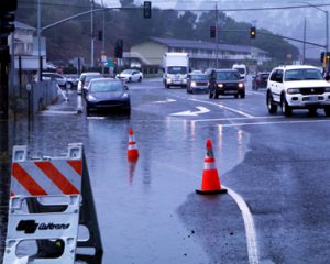
High tides often cause flooding along shoreline communities and low-lying roadways of Marin County, which can be exacerbated during winter storms. But tide-related flooding can happen whether it’s raining or not, and such inconveniences are likely over the next five weeks.
“High tides can bring localized flooding to coastal areas, such as Tam Junction, even on sunny days,” said Liz Lewis, Water Resources Manager for the Marin County Department of Public Works (DPW). “However, with saturated ground at this point in the rainy season, a strong storm coinciding with these high tides could increase impact to bay side areas of Marin, where signs of sea level rise are already showing.”
DPW and the Marin County Flood Control and Water Conservation District are urging residents and visitors to stay informed of changing weather conditions and be aware of expected high tides that might affect commuter schedules and travel plans. The California Department of Transportation (Caltrans) has preemptively closed the lower half of Manzanita Park & Ride in Tamalpais Valley Junction from January 6-14.
Caltrans, which oversees the parking lot, has made efforts in recent years to fortify the property. Additionally, DPW and the Flood District coordinated with Caltrans to install a 175-foot-long sandbag wall along Highway 1, adjacent to the Caltrans maintenance yard, where flooding from the bay historically inundates the road in front of Manzanita Park & Ride. However, when high tides are coupled with significant rain, localized flooding can still occur and limits access through the corridor. Commuters should expect delays and possibly detours during such incidents.
Based on tide predictions[External] published by the National Oceanic and Atmospheric Administration[External] (NOAA), tides levels that could be high enough to cause roadway flooding in parts of Marin, primarily coastal areas, are expected January 8-13, January 19-24 and February 6-10. Drivers are encouraged to consider using alternative routes and should allow extra time for trips, especially during peak commute times. Travelers should always avoid driving through ponded water, as even six inches of standing water can stall a low-clearance car.
The following chart shows predicted high tides at or above 6.3 feet during January and February at the San Francisco tide gauge[External], as provided by NOAA. If significant rainfall occurs during a high tide of 6.3 feet or more, the likelihood of localized flooding increases for coastal communities and other historically susceptible areas, such as North San Pedro Road through China Camp in outer San Rafael, Greenwood Cove Drive in Tiburon, and the preemptively closed section of Manzanita Park & Ride.
| Wednesday, January 8, 8:58 a.m. | 6.4 feet* |
| Thursday, January 9, 9:39 a.m. | 6.6 feet* |
| Friday, January 10, 10:22 a.m. | 6.7 feet* |
| Saturday, January 11, 11:07 a.m. | 6.7 feet* |
| Sunday, January 12, 11:54 a.m. | 6.6 feet* |
| Monday, January 13, 12:44 p.m. | 6.3 feet* |
| Sunday, January 19, 6:40 a.m. | 6.3 feet* |
| Monday, January 20, 7:31 a.m. | 6.4 feet* |
| Tuesday, January 21, 8:20 a.m. | 6.5 feet* |
| Wednesday, January 22, 9:06 a.m. | 6.5 feet* |
| Thursday, January 23, 9:51 a.m. | 6.5 feet* |
| Friday, January 24, 10:33 a.m. | 6.3 feet* |
| Thursday, February 6, 8:32 a.m. | 6.3 feet* |
| Friday, February 7, 9:21 a.m. | 6.5 feet* |
| Saturday, February 8, 10:10 a.m. | 6.7 feet* |
| Sunday, February 9, 10:59 a.m. | 6.7 feet* |
| Monday, February 10, 11:49 a.m. | 6.6 feet* |
*Tide Elevation (Mean Lower Low Water)
Future projections by the California King Tides Project[External] indicate that annual king tides, which are extreme high tides, could become the normal tides as sea level rise continues. King tides occur when the earth, moon and sun are aligned to exert the maximum upward gravitational pull on the tides, thereby increasing overall water elevations. The project also predicts that there will be an increase in daily tidal flooding. In the same vein, the County of Marin released the Marin Shoreline Sea Level Rise Vulnerability Assessment in 2017, a comprehensive study that showed the expected impacts that sea level rise will have on flooding in the region.
An example of impacted infrastructure is the multiple closures of Highway 37 near Novato in the past few years. The route along the San Pablo Bay marshlands, which is under the California Department of Transportation[External]’s (Caltrans) jurisdiction, is a crucial part of the North Bay’s road infrastructure. Studies are underway, including one by DPW, to assess the resiliency and potential solutions in the face of future sea level rise expectations.
As storms exacerbate high tides, DPW prepares year-round for the rainy season, conducting various maintenance tasks intended to help reduce the risk of flooding. In addition to maintenance tasks like creek clearing and storm drain cleaning, the Flood District has recently improved several infrastructure sites including a pump station in Tiburon and installation of new tide and creek level monitoring gauges.
Travelers can check 511.org[External] for latest traffic and transit information. DPW’s Twitter[External], Marin County Sheriff’s Office’s Twitter[External], the California Highway Patrol (CHP) traffic website[External] and CHP Marin’s Twitter[External] are excellent resources for travelers and residents looking for updates during storm events. Additionally, weather gauges showing rainfall and tide elevations can be viewed in real-time at Marin County’s OneRain webpage[External].