
For Immediate Release –
San Rafael, CA –
Tax measure fails; County to try to preserve federal funding and provide further flood protection efforts
With the recent failure of a neighborhood tax measure to fund enhanced flood protection, flood control engineers are assessing next steps to help protect against catastrophic property losses in the unincorporated Santa Venetia area of eastern San Rafael.
Measure A, a tidal flood mitigation measure for Santa Venetia in a low-lying community adjacent to San Francisco Bay, failed to pass during the March 2 special election. The measure secured significant community support with 66.29% approval but failed to meet the two-thirds majority requirement by three votes. The Marin County Elections Department confirmed the margin with a recount.
Given strong community support, the Marin County Flood Control and Water Conservation District and Marin County District 1 Supervisor Damon Connolly are looking to make adjustments and identify a successful path for Santa Venetia flood mitigation efforts.
“We remain committed to improving tidal flood protection in Santa Venetia,” Connolly said. “The community is in support of tidal flood protection. It is evident that we need to work together to rethink the approach, provide factual information, and address misinformation.”
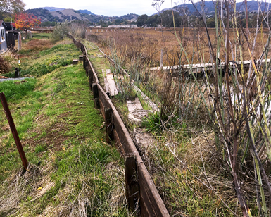
Measure A proposed creating a new subzone of Flood Control Zone 7, titled Subzone 7A, and establishing a $297 parcel tax for seven years for the Gallinas Levee Upgrade Project. The project would include obtaining easements and upgrading the timber-reinforced berm (TRB) along Gallinas Creek, effectively reducing the risk of tidal flooding for the proposed Subzone 7A. The risk of tidal flooding for the targeted area is increasing due to sea-level rise, land subsidence, and the deterioration of the existing flood barrier.
The levee between Gallinas Creek and the Santa Venetia neighborhood was initially raised in the 1980s with a TRB following several significant flood events. Located primarily on private property, the TRB has deteriorated over time to varying conditions and elevations.
Homeowners in Santa Venetia rely on a combination of flood mitigation infrastructure. The system is made up of storm drains, pump stations, bypass pipes, and the perimeter flood barrier system. Watershed studies point to the perimeter flood barrier as the weak link in the system. The flood barrier is composed of an earthen levee topped with a TRB.
The proposed project would rebuild the TRB to provide a 100-year level of protection with allowances for sea-level rise and land subsidence. A 100-year water level has a 26% chance of occurring during a 30-year period. On average, the top of the berm would be raised approximately 12 to 18 inches. The existing TRB would be replaced within its current footprint.
The new TRB would be built of composite material and embedded deeper into the levee to offer greater flood protection. The underlying earthen levee will not be rebuilt. Based on sea-level rise projections and land subsidence rates, the proposed project would offer 100-year flood level protection until approximately 2050.
“Community feedback made it clear that there was confusion around the necessity of securing easements from property owners along Gallinas Creek,” Connolly said. “The easements are crucial for current maintenance needs and onwards into the future. The confusion is in part how each homeowner’s unique situation is impacted, and we aim to address those questions fully.”
Currently, the Flood Control Zone 7 staff cannot access an estimated 10% of the existing TRB to conduct regular maintenance and inspection. A single weak point in the flood barrier places the whole community at risk. To ensure ongoing maintenance and inspection, as well as potential construction of a new berm, the District needs to purchase easements from approximately 100 private parcels along the levee. The clarity would be beneficial before voters have another opportunity to decide on the proposed TRB project.
The proposed TRB project, including easement acquisition, engineering design, environmental compliance, permitting and construction, is estimated to cost $6 million. The actual costs of securing the easements will depend on appraisals.
The appraisal process will be underway in a phased approach over the next several months. Funding for easement acquisitions would come from a combination of Flood Control Zone 7 and County funds. A FEMA Grant awarded will contribute $3 million for most of the construction and requires local matching funds. The grant is set to expire in February 2022. The County may seek a one-year extension after demonstrating progress.